MARYSVILLE — For some time, City Hall officials have said they want lots and lots of light industrial and commercial growth in most of the largely undeveloped area north of 152nd Street NE.
But Community Development Director Gloria Hirashima said what the city is really after is a “high quality business environment.”
Toward that end, officials have been working at least since roughly spring of 2007 on a new master plan for the area, part of the Smokey Point neighborhood.
Drawing together a small number of Marysville officials, property owners and other interested residents, the city held an open house on the plan April 15.
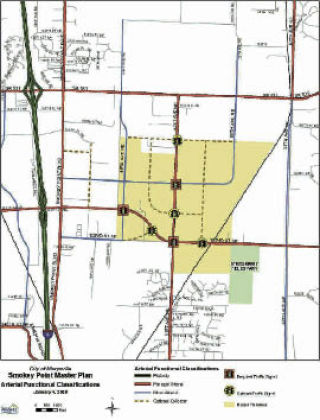
What the city calls the Smokey Neighborhood Planning area covers some 1,859 acres, with the area affected by the industrial plan covering about 675 acres. While the industrial planning area’s southern border is 152nd Street, the area runs north to 172nd Street, west to 43rd Avenue and east to the Burlington Northern Railroad tracks.
Noting that everything depends on infrastructure, roads were the key item on the minds of property owners at the session, which turned into an informal discussion. Noting that for various reasons, the southwest corner of the planning area might see the quickest development, property owners zeroed in on the city’s road plan for that spot.
Essentially, the city wants to extend 156th Street NE all the way to 43rd Avenue NE, where it would dip down to meet 152nd Street. Property owner Jim Tosti presented an alternative plan that would place the dip to 152nd further east, beyond 51st Avenue NE. Totsi and others said the alignment would allow better development of the southwest corner of the industrial area.
Hirashima and others, including city consultants, said the Totsi plan is viable, but they want to ensure a link between 156th Street and 152nd Street. Planning Commission Chair Steve Muller said all suggestions would receive due consideration. Officials said the ultimate configuration of the roads and, in fact, the ultimate development of the area, depends to a large extent on whether or not the city can pull off an interchange between I-5 and 156th Street
Predictably, how to pay for road and other improvements is a big question. At least regarding streets, formation of so-called Road Improvement Districts might be one answer. Property owners reported they already are circulating petitions to form at least one such district in the southern part of the planning area.
Hirashima said state law allows for formation of the districts if a certain majority of affected property owners approve of the idea. Public hearings and other formalities must be dealt with, but the goal is for the city to undertake road improvements, assessing landowners for the cost.
Marysville has not used road districts for sometime, Hirashima added, but said they can allow quick development of underutilized areas. They also can allow property owners to take advantage of long term, low-interest financing available to the city.
If everything falls into place, how soon might new roads appear? Totsi and other property owners talked about completing designs for roads this year, with construction starting as soon as next year.
Besides roads, Hirashima said the city faces a number of other key challenges, including dealing with wetlands and streams. Drainage issues could prove significant. Officials also are looking carefully at architectural design schemes, looking for uniformity in the look and feel of the businesses moving into the area.
“We want it to look really cohesive,” Hirashima said.
Regarding design, at one point, the 200-plus-page master plan refers to efforts to bring the “typical light industrial or commercial development to a higher level of urban design.” The plan goes into enough architectural detail to discuss modulating long stretches of blank wall. Not incidentally, landscaping requirements are part of the mix. Plans also mandate the inclusion of walkways and other pedestrian right-of-ways. Within its planning document, the city points to several examples of what local officials feel are successful business developments elsewhere, such as buildings and business parks in Bothell and Issaquah.
While Hirashima said the city is looking for uniformity and a certain quality of design, there is some room for give and take built into the design requirements.
“We’ve put in some pretty flexible designs,” she said. “There are some things that are musts.”
What happens next? Hirashima said the planning commission will hold one more work session on the plan, then call for a formal public hearing possibly for sometime next month. From there, the whole issue goes to City Council for ultimate approval.