MARYSVILLE Its a tale of two roads that both lead to the land of NIMBY: Not in my back yard.
Only the new roads people in the Sunnyside and Whiskey Ridge are fighting would literally run through some families back yards.
And now opponents of the road scheme for the newly annexed east Sunnyside and Whiskey Ridge neighborhoods have won another round before the Marysville Planning Commission.
The commission unanimously voted to remand two plans back to city staff for more study at a July 24 meeting at City Hall. Opponents said engineers were using stale data for two new possible major arterials in the citys south side, and the commissioners agreed. One said that in 14 years serving on the panel he has never seen such a well informed and cogent argument put forward by lay people against the notions formulated by the citys professional engineering and planning staff.
The options presented by staff are not good options, commissioner Dave Voigt said. The [traffic] modeling I think, was very weak.
The city would be going out on a limb with the outdated modeling planners were using, according to Voigt, who moved to send the road plans back to city staff for the necessary updated traffic modeling and more accurate costs.
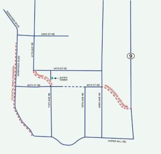
Most of those issues were concerned with a new route to connect the citys road grid to SR 9 at Marysvilles southeast boundaries where the state highway meets Soper Hill Road, near the city of Lake Stevens. Many new city residents living in the Sunnyside neighborhood are caught right in the middle where planners are routing a pair of new north-south and east-west routes. Currently the idea is to connect 67th Avenue to 71st Avenue by building a curved segment between 40th and 44th streets NE. That would cut up as many as 14 different parcels, affecting several families who hired a land use lawyer to challenge one part of the plan.
Ideally the city wants a five-lane route to draw traffic from Sunnyside Boulevard and 67th Avenue, funneling it up a steep hill to 71st Street NE, near the city-owned water tower. Marysville leaders say they need to get it right the first time with the plan, which will set zoning and land uses in the 1,535-acre area for the next decade. But routing a main line near the water tank has upset many residents who want to keep their land and homes in the rural community.
Some suggested looking at widening Sunnyside Boulevard south to where it now curves abruptly to meet Soper Hill Road. Widening Sunnyside for only 1.8 miles could cost at least $35 million and would impact as many as 100 different properties, community development director Gloria Hirashima and city engineer Kevin Nielsen told the commission.
That figure was probably much lower than actual costs since it didnt include many other requirements for widening the boulevard, according to Nielsen, who didnt get much traction with Voigt and the other commissioners, who required staff to look at making the route the principal connector.
Id like Sunnyside to be examined more closely, Voigt said, adding that he wanted planners to exert every effort to use existing roads and rights-of-way.
The other planned road is also connector about a half-mile east of Sunnyside Boulevard near SR 9. Engineers are looking at designating 87th Avenue NE as another primary connector with an east-west arterial at about 40th Street NE. The exact location of the final route is still in flux but locals are firm in their opposition.
Ken White lives on 87th and said widening that road would require right-of-way that would disproportionately affect owners of smaller properties.
It would be very disruptive to the neighborhood, White told the commission, adding that they shouldnt be working with stale data when routing roads through his stomping grounds. I dont think a decision can be made with outdated information.
White stressed that he and his friends werent against development or the long-range planning Marysville was conducting, just disappointed that there were so few opportunities to hear from the people who will be impacted the most by the commissions decisions. Several workshops were held by the commission for members to discuss the plans, but that generally doesnt include participation from community members.
That doesnt make sense to me, White lamented. Talk with us, maybe we have some solutions, we have ideas. We want to work with you with some of these decisions.
Commission chairman Steve Muller tried to calm the fears of the 50 people present, reminding them that none of these roads will be built by the city, and not any time soon. By designating the principal routes now, the city can require developers to provide the right-of-way and build the roads as part of the permitting conditions. In essence, Muller said the property owners dont have much to be afraid of if they are not planning to develop their plots.
Deirdre Kvangnes said she has lived in town for 40 years and served on the planning commission for eight, and that Marysville is way behind the eight-ball where traffic and transportation infrastructure are concerned. That starts with planning and she asked the sometimes emotional folks in the audience to stay involved in the process.
We have to fix traffic in our town, Kvangnes warned.
The commission is considering the plan for the third time now, after an initial master plan met resistance from the same property owners earlier this year. There were about 2,500 people living in the area when it was annexed by the city in December 2006 and that could swell to 10,000 over the next 15 years as more homes and businesses are built.
NIMBY wins round 3 in Mville plan for roads
MARYSVILLE Its a tale of two roads that both lead to the land of NIMBY: Not in my back yard.