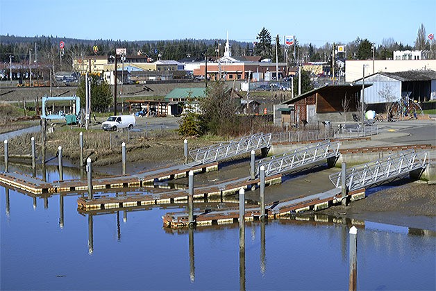
MARYSVILLE – Imagine kayaks, canoes, paddle boards and other light watercraft traveling along Ebey Slough.
At high tide they would be able to paddle into the Qwuloolt Estuary for adventure, fellowship and exercise. Families, individuals and groups could all enjoy and learn from this relaxing experience. Locals and tourists could participate.
On their excursion they could stop at places along the slough to picnic and read interpretive signs. They could visit with people who were walking, riding bikes or online skating along the trail, which will meander along the slough.
And when they are done they could take their rental boats back to the Light Watercraft Center at the Ebey Waterfront Park.
That is a vision consultant Carol Mayer Reed shared with the Marysville City Council Feb. 22. Her Portland firm was hired to come up with a draft master plan for the Marysville Waterfront Park and Trail.
City staff emphasized this is very early in the planning stages.
Reed said the waterfront is underutilized.
“It’s been a dead end. Everybody turned their backs on it for decades,” she said.
Because it’s on the back side of the mall, Reed said it would be important to bring in businesses that would face the park. Eating areas, a coffee shop and/or a business related to a marina would suffice.
Reed predicted a Light Watercraft Center would be popular.
“The Northwest has an affinity for the water,” she said, adding that a 4,800-square-foot, two-story building with a deck would be big enough to attract attention from motorists on Interstate 5.
The vision goes far beyond water activities, however.
Reed also showed a design for the park to include two areas where performances could take place. One is near First Street. It could be where entertainment takes place while a street fair or Farmer’s Market was going on. The other location is closer to the pond, where a slope would be made so people can watch events downhill on a permanent or temporary stage.
“People will approach you with all the programs they can dream up for it,” Reed said.
Other ideas include walkways for strolling, a sculptured play area and a flexible lawn with hammocks. The pond could be used for safety education and training. A boardwalk along the water could include benches and a railing. Floating docks could house concessions part of the year.
Reed also talked about the trail system.
Starting from the east, the public would have access from a new Olympic View Park. There would be a switchback trail, play area and a steep driveway so visitors could put watercraft in the slough there close to the estuary.
Nearby Harborview Park would be enhanced to be more of a public rather than neighborhood park, with more play areas.
Heading toward Sunnyside Boulevard, consultants envision a scenic overlook so visitors can take in the estuary with the Olympic mountains in the background on a clear day.
A path would be made along the estuary to Allen Creek. A bridge would be needed there and connect to a trail to be built along the new levee east of the sewage treatment plant. The trail then goes east toward the breach at the opening of the estuary or west to the waterfront park. To the east would be an outdoor classroom. To the west a more-decorative fence than chainlink would keep people from the treatment plant. Art, fishing platforms and resting spots also are planned. Walkers, bikers and skaters would go under the Highway 529 bridge to reach the park.
Parks, Culture and Recreation Direct Jim Ballew said taking advantage of fish life in the slough also should not be forgotten. He said silver salmon fish runs are especially impressive.
“That’s an opportunity,” he said.
Council Member Stephen Muller was concerned about the lack of parking.
“We all anticipate this to be a destination,” he said.
Reed said it can be tough to figure out how many parking spots would be needed.
“We don’t know how many people will use this and what they would need,” she said.
Chief Administrative Office Gloria Hirashima said the consultants did just what was asked of them.
“This is big picture,” she said. “We can approach it in stages.”
Ballew said there would be the potential for grants for the project.
“We can figure out a way to make this happen,” Hirashima said.
But Muller asked why not do it all at once? He suggested that the city could ask the voters to pass a bond.
“I wouldn’t be afraid to ask the voters,” he said. “This would be good for everybody.”
Mayor Jon Nehring said the project would have to be done right. He said he doesn’t think the plan should be trimmed too much.
“We could spend a lot of money, but if it doesn’t pop,” residents won’t go for it, he said.
Muller said the city has looked at a lot of options over the years for the waterfront.
“This is the most feasible, something we could do in our lifetime,” he said.
Cost for the 3.8 miles of trails and amenities would be about $11 million. Cost of the park and amenities would be $15 million.
The most-costly items would be:
•Site preparation and demolition, $2.32 million.
•Light watercraft center, $2.2 million.
•Utilities, $1.8 million.
•Waterfront boardwalk, $1.76 million
•Site development, $1.47 million
•Boardwalk promenade, $1.32 million.
•Boat basin, $1.319 million